UNESCO WORLD HERITAGE SITE
History of the fort
Rohtas Fort, built in the 16th century at a strategic site in the northern part of Punjab, Pakistan, is an exceptional example of early Muslim military architecture in central and south Asia. The main fortifications of this 70-hectare garrison consist of massive masonry walls more than four kilometers in circumference, lined with 68 bastions and pierced at strategic points by 12 monumental gateways. A blend of Turkish, Middle-Eastern, and South Asian architectural and artistic traditions, the Fort had a profound influence on the development of architectural style in the Mughal Empire.
Rohtas Fort was built by Sher Shah Suri, who became Emperor of the Sur Empire in India in 1540 A.D. by dethroning the Mughal Emperor Humayun. Sher Shah Suri had a great passion for the construction of forts, mosques, roads, serais (inns) etc.
For Sher Shah, construction of the Rohtas Fort was a significant part of his strategy to consolidate his hold over the region, and ensure that Humayun would not be able to stage a comeback. Sher Shah also wanted to extend control over the Ghakhars – powerful native tribes of the Salt Range who were loyal allies of the Mughals.
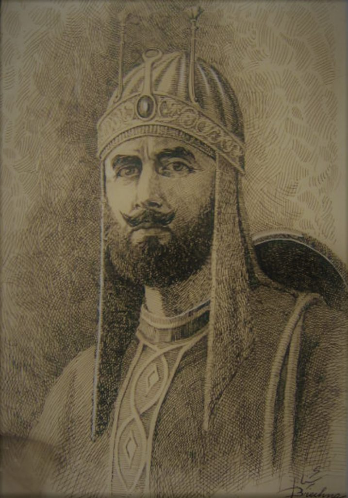
Sher Shah Suri
Sher Shah Suri (1486 – 1545), was the founder of the Suri Empire, with its capital at Sasaram in modern-day Bihar, India. An ethnic Afghan ruler, Sher Shah took control of the Mughal Empire in 1540, and commissioned the construction of the Rohtas Fort soon after.
His military career began as a soldier in the Mughal Army under Emperor Babur. He rapidly rose through the ranks to become a commander, and eventually the governor of Bihar. Legend has it that he earned his title of Sher Shah by single-handedly killing a tiger while serving as governor. In 1537, when Emperor Humayun was elsewhere on an expedition, Sher Shah swiftly took control of the state of Bengal and established the Suri dynasty. A keen strategist, Sher Shah proved himself a gifted administrator as well as a capable general.
During his five-year rule from 1540 to 1545, he set up a new economic and military administration, issued the first Rupiya as currency, and organized the postal system of the Indian Subcontinent.
Sher Shah further developed Humayun’s Din-panah city and renamed it Shergarh. He also revived the historical city of Pataliputra, which had been in decline since the 7th century A.D., and renamed it Patna.
He extended the Shahrah-e-Azam (Grand Trunk Road) from the province of Bengal in northeast India to Kabul in Afghanistan in the far northwest. The influence of his innovations and reforms extended far beyond his brief reign. Throughout his reign, he reportedly never lost a battle. Even his arch nemesis, Humayun, referred to him as “Ustad-e-Badshahan” – teacher of kings. Many of his institutional reforms paved the way for the later Mughal Emperors, especially Humayun’s son Akbar. After Sher Shah’s untimely death in 1545, he was succeeded by his son Islam Shah.
Architectural Features
The design of Rohtas Fort was inspired by the Rohtasgarh Fort in Bihar, which Sher Shah had conquered in 1539 A.D. Rohtas Fort has the capacity to hold 30,000 troops in its vast 800,000 square meters of space. The fort was designed to both utilize and withstand gunpowder warfare, which had arrived in India with Babur and his Turkish cannons. It is irregular in plan, with deep ravines and gorges on all sides and the River Kahaan providing further defence to the North, West and East.
Rohtas Fort is truly unique. There are no surviving examples on the subcontinent of military architecture of this period on the same scale and with the same degree of completeness and preservation.
The cost of construction in today’s money would be approximately $230 million. The main gate is the Khawaskhani Gate in the North. The garrison area or “Berunkot” (Outer Court) of the fort lies to the left (East) when entering and the citadel or “Andarkot” (Inner Court) area is to the right (West). Both are divided by a 533m wall with a single gate in between.
The citadel housed the military and royal leadership, and contains the Shahi Masjid, Haveli of Raja Man Singh (Mughal Emperor Akbar’s general) and a monumental “baoli” or stepwell for collecting water for the troops.
The Berunkot was mostly for troops and their allied facilities, and contains 5 tanks and 1 large stepwell along with some now defunct Hindu temples.
Built with coarse rubble, brick and ashlar sandstone masonry, the fort very successfully portrays its strength in its design. The walls range from 10-20 m high and 12 m thick at their widest, with three terrace levels on the inside having an average width of 2.5m and connected via stairways.
The fortification wall is surmounted by merlon shaped battlements, which range in height from 2.5m to 3.5m, being 1m thick. Machicolations are present in all battlements for the use of muskets, arrows, or boiled liquids against invaders. The thick walls have vaulted galleries in them both for storage and to house the many troops needed to man the fort.
It is located on the main route of the Shahrah-e-Azam which was formally established by Sher Shah, connecting Sonargaon in Bengal in the East with Peshawar in the West. Rohtas Fort is ideally situated to control the movement of armies, people, and goods through this narrow track. The garrison complex was in continuous use until 1707 A.D., and then reoccupied under the Durrani and Sikh rulers of the 18th and 19th centuries respectively. Over time, a village grew within the fort walls, and exists today.
The fort was declared a protected monument in 1919 A.D. during the British Raj, and subsequently inscribed on the World Heritage List by UNESCO in 1997 A.D.
Our Supporters